Showing posts with label Burren. Show all posts

Tuesday, April 14, 2015

Corcomroe Abbey -- Ireland


Corcomroe Abbey in The Burren
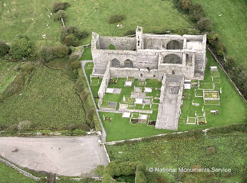
Located in a fertile green valley of the Burren, County Clare, Ireland, the ruins of Corcomroe Abbey are remarkably well-preserved.  Uniquely picturesque in its isolation on the Burren, the abbey is situated close to three small deserted Christian churches dedicated to St. Colman and nestled in the pass of Oughtmana.

Early monks sought out isolated areas to settle and became self sustained.  The abbey became known as “Sancta Maria de Petra Fertili”—St. Mary of the Fertile Rock, as the Burren provided all the monks needed to maintain a Cistercian community through cultivating the surrounding fertile lands.

Corcomroe Abbey is said to have been established by Donal Mór Ua Briain in the late 12th century and continued to function for the next 400 years.  The last abbot named was John O'Dea, a Cistercian from the Irish College at Salamanca, in 1628.

The abbey is noted for its beautiful architectural detail still visible in its ruinous state and not found in other structures of this period.   It features a typical cruciform church facing east, with a small chapel in each transept. 

Magnificent arches still reign over chapel entries, although one entrance has been sealed off for burials—both ancient and modern.  Parts of the remaining roof still bear some finely carved rib vaulting in the Romanesque style.

Capital details - human masks and floral detail
The capitals are decorated with lotus leaves and other botanic detail, while some carved human masks and dragon heads are visible in the transept chapels.

The choir is constructed with high quality stonework and in the north wall can be seen a tomb-niche holding a recumbent effigy of King Conor na Siudaine Ua Briain who died in 1267, one of the very few examples remaining of an Irish Chieftain.  He was a benefactor of the abbey and grandson of the founder. 

Effigy of King Conor na Siudaine Ua Brianin
The English Reformation led to the dissolution of Catholic monasteries in England and Ireland. In 1554, the abbey was granted to the Earl of Thomond

The site is under state care and a National Monument of Ireland.  The graveyard surrounding the abbey is still in use, so care must be taken not to disturb the site.

Look for the ring fort dissected by the road on the way out, identifiable by the raised circular mound topped by hawthorn trees.

Saturday, February 28, 2015

The Burren in Western Ireland

Rolling hills of The Burren
 Not far from the Cliffs of Moher in the west of Ireland lies The Burren, or "Boíreann" meaning a rocky place.  And it is that indeed...close to 125 square miles of limestone rock covering imposing majestic mountains and tranquil valleys with gently meandering streams.  Geologists marvel at underground rivers, caves, depressions, plateaus, and other fascinating geological formations.

Formed millions of years ago under a tropical sea and later carved by glaciers, the flowing ice rounded the hills and left deposits of huge boulders and criss-crossing cracks known as "grikes."  This erosion process left a barren landscape, however it has been referred to in the past as "fertile rock" due to the mixture of nutrient rich herb and floral species.   

In 1651, a Cromwellian Army Officer named Edmund Ludlow remarked, "of this barony it is said that it is a country where there is not water enough to drown a man, wood enough to hang one, nor earth enough to bury them. This last is so scarce that the inhabitants steal it from one another and yet their cattle are very fat. The grass grows in tufts of earth of two or three foot square which lies between the limestone rocks and is very sweet and nourishing."

The Burren region is internationally famous for its landscape and diverse flora.  Summer visits treat the visitor to a colorful array of plants and flowers.  Over 600 different flowering plants have been recorded in the Burren.  Arctic, alpine, and Mediterranean plants thrive side-by-side.

Megalithic tomb - Poulnabrone
The area is also known for more than 90 megalithic tombs, monuments, and ring forts, older than the Egyptian pyramids.  One of the more famous megalithic tombs, the portal dolmen at Poulnabrone, dates back to around 2,500 BC.  'Dolmen' is Breton for 'table', which is what a dolmen looks like - a large capstone on two or three standing stones.

The ring forts also testify to human presence on the Burren, among them the triple ring fort Cahercommaun on the edge of an inland cliff, and the exceptionally well-preserved Caherconnell Stone Fort.

A stop at the Burren Vistor Centre in the picturesque village of Kilfenora, Ireland’s first interpretive centre, presents a 12-minute film that introduces the visitor to this unique and fascinating region.  The exhibition area enables the visitor to experience the development of the Burren and its civilization from formation 320 million years ago to how the Burren is today.

The centre also hosts a celebration of traditional Irish music dedicated to the history and music of  The Kilfenora Céilí Band.

Enjoy this overview video of The Burren (6:39).